Randonnée Marche La Ferrière-aux-Étangs - La Ferrière - La Ferrière aux Etangs - Photo

La Ferrière - La Ferrière aux Etangs

 tracegps
tracegps

Utilisateur

© OpenStreetMap contributors
Longueur
Longueur
14,3 km
Altitude max
Altitude max
297 m
Dénivelé positif
Dénivelé positif
273 m
Km-Effort
Km-Effort  
17,9 km
Altitude min
Altitude min
195 m
Dénivelé négatif
Dénivelé négatif
273 m
Boucle
Boucle
Oui
Date de création :
2014-12-10 00:00:00.0
Dernière modification :
2014-12-10 00:00:00.0

(0 Avis)

Marche
Marche
3h04
Difficulté : Moyen

Scannez ce code QR pour ouvrir la randonnée dans l'application SityTrail

Application GPS de randonnée GRATUITE

Logo SityTrail SityTrail

IGN / Instituts géographiques

Télécharger SityTrail sur l'App Store Télécharger SityTrail sur Google Play

Logo SityTrail SityTrail World

Le monde est à vous

Télécharger SityTrail sur l'App Store Télécharger SityTrail sur Google Play Télécharger SityTrail sur Huawei AppGallery

À propos

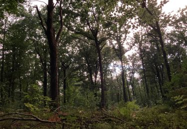
Randonnée Marche de 14,3 km à découvrir à Normandie, Orne, La Ferrière-aux-Étangs. Cette randonnée est proposée par tracegps.

Description

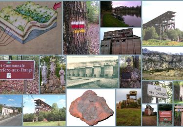
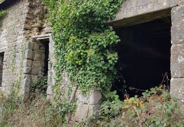
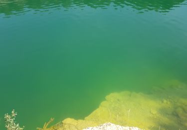
La Ferrière - La Ferrière aux Étangs Au cœur du Bocage, les traces anciennes et modernes de l'exploitation du minerai de fer sont encore présentes dans la mémoire des hommes et dans le paysage. Retrouvez les Coup de Cœur Randonnée dans l’Orne en Normandie.

Profil altimétrique

Photos

Localisation

Pays :
France
Région :
Normandie
Département/Province :
Orne
Commune :
La Ferrière-aux-Étangs
Localité :
Unknown
Départ:(Dec)
Départ:(UTM)
682666 ; 5392696 (30U) N.

Randonnées à proximité

Randonnée Marche La Ferrière-aux-Étangs - Circuit of IRON by Yannick-p14-61 - Photo
Marche
yannick-p

Marche

Moyen
(1)
La Ferrière-aux-Étangs, Normandie, Orne, France
13,3 km | 16,5 km-effort
3h 35min
Oui
Randonnée Marche La Coulonche - La coulonche - Photo
Marche
Elisabeth Neveu

Marche

Très facile
La Coulonche, Normandie, Orne, France
3,7 km | 4,9 km-effort
1h 22min
Oui
Randonnée Marche La Ferrière-aux-Étangs - 1h16 - Photo
Marche
Jeromefrando

Marche

Moyen
La Ferrière-aux-Étangs, Normandie, Orne, France
6,4 km | 8,5 km-effort
1h 16min
Oui
Randonnée Marche Le Châtellier - chatellier - Photo
Marche
sitydomer

Marche

Moyen
Le Châtellier, Normandie, Orne, France
6 km | 6,6 km-effort
1h 36min
Oui
Randonnée Marche Dompierre - mines - Photo
Marche
canal

Marche

Moyen
Dompierre, Normandie, Orne, France
9,3 km | 11,6 km-effort
2h 47min
Non
Randonnée Marche La Ferrière-aux-Étangs - La Feriere aux etant  - Photo
Marche
Elisabeth Neveu

Marche

Très facile
La Ferrière-aux-Étangs, Normandie, Orne, France
1,2 km | 1,3 km-effort
36min
Oui
Randonnée Marche Dompierre - Dompierre; trace GPS du 10/09/2019 - Photo
Marche
toporient

Marche

Très facile
Dompierre, Normandie, Orne, France
8,2 km | 10,2 km-effort
4h 30min
Oui
Randonnée Marche Dompierre - Dompierre longue - Photo
Marche
toporient

Marche

Moyen
Dompierre, Normandie, Orne, France
8,3 km | 10 km-effort
2h 13min
Oui
Randonnée Marche La Coulonche - La Coulonche Est et Ouest - Photo
Marche
toporient

Marche

Facile
La Coulonche, Normandie, Orne, France
7,5 km | 9,3 km-effort
2h 0min
Oui


Fermer
Mes abonnements